July 1934 Radio News & Short-Wave |
 [Table
of Contents] [Table
of Contents]
Wax nostalgic about and learn from the history of early
electronics. See articles from
Radio & Television News, published 1919-1959. All copyrights hereby
acknowledged.
|
Before the Internet, cellphone
apps, and personal computers, many calculations began with a lookup table, chart,
or nomograph. In the case of long distance radio operators [Ham, Short Wave Listener
(SWL), and professional types] seeking distance and direction information for pointing
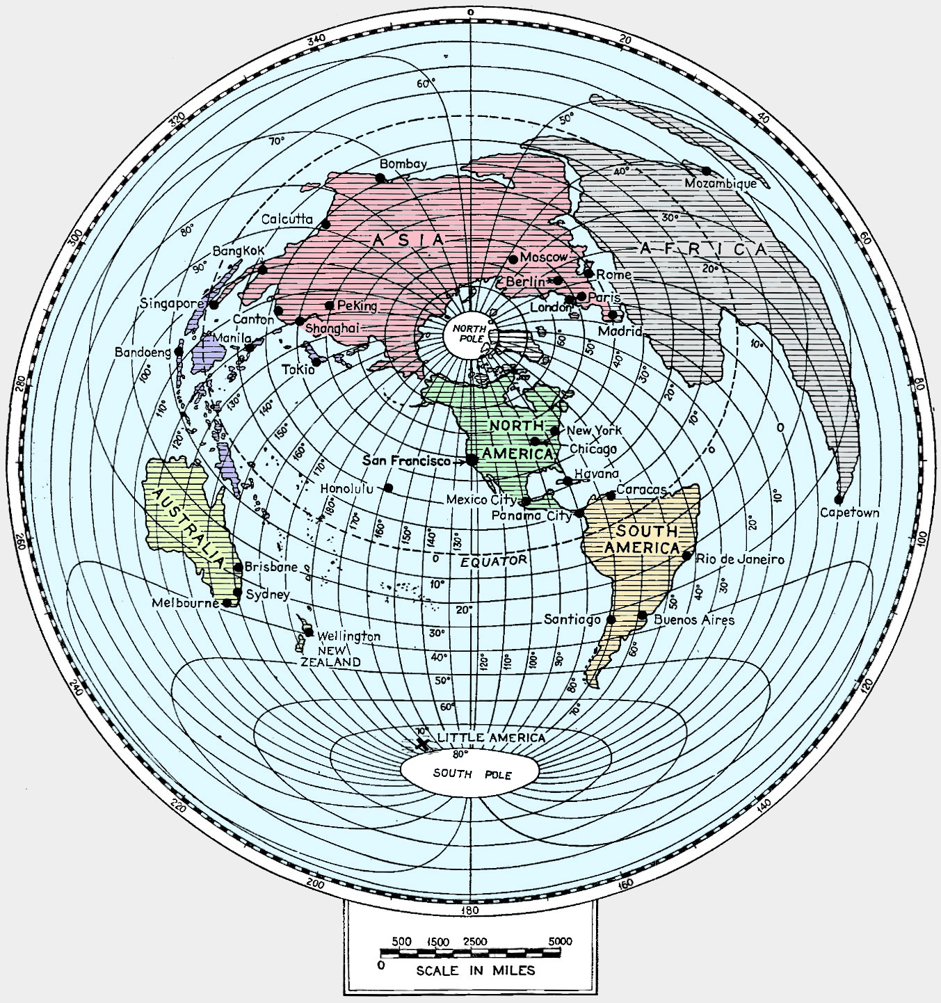
antennas, it took a map like this one published by Radio News & Short-Wave
magazine in 1934 to estimate an optimal configuration. Such tools were essential
in order to determine the best direction to point the antenna, which over a long
distance is usually much different than what might be assumed by looking at a flattened
projection map of the earth (see "Distance Lends Enchantment" below). Distances
in Chart No. 1 are all relative to New York (NYers have always considered themselves
the center of the universe  ), so operators in other locales
need to compensate. Here is one example of many online
great circle calculators
that allows you to enter two sets of longitude and latitude. World Distance Chart
No. 2, centered on San Francisco, was published in the August 1934 issue and
is reproduced below as well (added 12/2019). ), so operators in other locales
need to compensate. Here is one example of many online
great circle calculators
that allows you to enter two sets of longitude and latitude. World Distance Chart
No. 2, centered on San Francisco, was published in the August 1934 issue and
is reproduced below as well (added 12/2019).
World Distance Chart No. 1 - How to Use the World Distance Chart
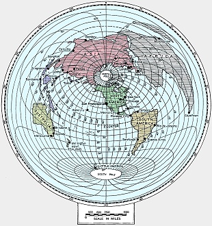
World Distance Chart No. 2 - Centered on San Francisco
World Distance Chart No. 1 - Centered on New York City
To use the map first find the distance in inches between New York and the desired
point, multiply this by the miles per inch shown on the scale on the chart and the
answer will be a close approximation to the air line distance between the two points.
This chart is reproduced from the March, 1933, issue of Radio News for
the benefit of our new short-wave readers. Chart Number Two will be published next
month.
"Distance Lends Enchantment"
In the realm of "DX," a term which in radio parlance means "long distance," the
actual distance in miles is the yardstick of accomplishment. The distorted map shown
here permits direct measurement of the mileage between New York and any point in
the world, or from any point in the world to New York, without calculations or computations
and with an ordinary ruler the only instrument needed. To use the map, first find
the distance in inches between New York and the desired point, multiply this figure
by the miles per inch shown on the scale on the chart and the answer will be a close
approximation to the exact airline distance between the two points. Distances from
points other than New York can in many cases be closely approximated by reference
to New York. To determine the distance between San Francisco and Melbourne, Australia,
for instance, the distance from Melbourne to New York is found and from this is
subtracted the distance from San Francisco to New York. The distance between San
Francisco and a point in Africa would be obtained in the same manner, except that
the mileage between San Francisco and New York would be added to the distance from
New York to the African point. An important feature of this map is found in the
fact that one can easily see the shortest straight-line path from any point in the
world to New York, and the exact direction of such a path. Thus, it is surprising
to learn that radio signals from Tokyo or Manila pass almost directly over the North
Pole in their path to New York, whereas most people think of such signals as coming
to New York from a westerly point, probably passing over Los Angeles en route. Based
on map furnished through courtesy of General Electric Co.
World Distance Chart No. 2
Here is the azimuthal map centered on San Francisco for reckoning distances from
there to any other location in the world. To use the map find the distance between
San Francisco and the desired location and refer this to the scale in miles printed
above to find the actual distance. This is the world distance chart No. 2. Distance
chart No. 1, published in the July issue, showed a map centered on the East American
Coast at New York.
Posted April 25, 2024
(updated from original
post on 7/29/2013)
|