|
May 18, 1964 Electronics
 [Table of Contents] [Table of Contents]
Wax nostalgic about and learn from the history of early electronics.
See articles from Electronics,
published 1930 - 1988. All copyrights hereby acknowledged.
|
This story from a 1964 issue of
Electronics magazine is close to home - literally. Well, it was close to
home at the time, anyway. It reports on the work done by the Electromagnetic Compatibility
Analysis Center (ECAC)* "...jutting out on a pier across the broad Severn River
from the United States Naval Academy at Annapolis." I grew up in the 1960s and 70s
just a few miles from there and distinctly recall seeing all the antennas in the
area, including the now decommissioned and removed acres-big
ELF (extremely low frequency, 30 to 300 Hz)
submarine communications antenna farm. The Annapolis location, with its proximity
to Washington, D.C., was the home to many government and military installations
and defense contractors. It was an electromagnetic signal-rich environment, which
made it the perfect setting for studying compatibility issues. Editor John Carroll
wrote this rather extensive review of the state of the art for the era, although
no doubt the true extent of the capability was known only to those possessing security
clearances.
* ECAC published a very nice
Field Antenna Handbook in 1984.
The Quest for Tx/Rx Compatibility

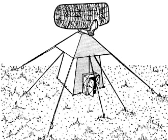
Air Force AN/FPS-35 search radar is replacing older radars to
enhance the capability of the SAGE system. But these newcomers are potential interference
problems in some areas.
Thousands of mutually interfering transmitters and receivers make military operations
an electronic Babel, but our armed services may have found one solution.
By John M. Carroll
Managing Editor
Jutting out on a pier across the broad Severn River from the United States Naval
Academy at Annapolis is an unimposing structure best described architecturally as
"warehouse modern."
It is, nevertheless, the nerve center of a tri-service effort to eliminate radio
frequency interference in research and development stages and to provide technical
coordination for military frequency allocations.
The Electromagnetic Compatibility Analysis Center is run by the Air Force with
representation from the Army, Navy and Marines. A contractor, Illinois Institute
of Technology Research Institute, handles data processing and computer programing.
Basically the center has the mission of assembling a data base of spectrum signatures
(or transmission characteristics), deployment and operation of all electromagnetic
equipment anywhere in the world, carrying out an engineering analysis program, and
supplying the services with technical advice both in research and development of
electronic equipment and in allocating radio frequencies to military organizations.
The Interference Mess
This help is badly needed too.

Marine Corps AN/TPS-1 battlefield surveillance radar has already
figured in four-service study of electromagnetic compatibility. Other participants
were Navy AN/SPS-6, Army AN/FPS-36 and Air Force AN/FPS-7

Marine Corps Tactical Air Control Center is representative of
transportable equipment that can radically change the electromagnetic environment
of an area when it is moved in.

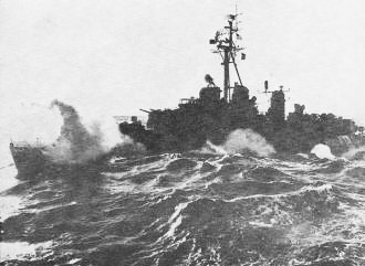
Navy AN/SPS-6C surface search radar seen at yard-arm height on
main mast of the destroyer Ingraham has already been a participant in compatibility
analysis studies.
Launch of a super-rocket at Cape Kennedy was delayed more than an hour when the
radar of a ship offshore interfered with a critical tracking radar on the missile
range. The Navy had to spend a million dollars reworking radar altimeters erroneously
designed to operate in the wrong frequency band. A taxicab driver in Texas detonated
a missile at Cape Kennedy. The job of locating intrasystem interference that caused
the altimeter of an RB-47 jet bomber to malfunction cost $180,000. And new AN/FPS-24
radars installed near Pittsburgh and Almaden, Calif. have local residents up in
arms over interference to radio, tv and hi-f .
And there is more trouble to come as the existing AN/FPS-20 search radar and
AN/FPS-60 height-finders of the North American Air Defense Command are replaced
by new and more powerful frequency-diversity units such as the AN/FPS-24, 35, 27
and 7 search radars and the AN/FPS-26 height finder. Powerful new radar for the
Space Detection and Tracking System (Spadats) will give even more trouble.
Problems to Be Solved
The Center receives its frequency-allocation problems from JF-12, a working group
of the Joint Frequency Panel of the Joint Chiefs of Staff. It receives its design
problems from the office of the deputy secretary of defense for research and engineering.
Its method consists of defining the problem, translating it into terms used by the
center, computing, performing engineering analysis and retranslating the problem
into terms used by the poser. The tools the center uses are broad-gage data files
on equipment environment, operating characteristics and terrain and an impressive
library of mathematical models and computer programs. Problems are solved on the
equipment component level (interference within a specific receiver or transmitter)
the intrasystem level (such as aboard a particular missile or aircraft), the inter-system
level (between ships and aircraft, for example) or on the total electronic environment
level.
The center has worked on a problem of interference between uhf radar and airborne
tactical data links in the Montgomery Air Defense Sector. It has studied interference
problems of AN/TPS-1D and AN/SPS-6C radars at the equipment level in the Naval Aeronautical
Navigation Experimental Project at Patuxent River, Md.
It has studied one-to-one interference (one transmitter interfering with one
receiver) assuming both smooth-earth and terrain reflection propagation at Rome
Air Development Center between TPS-1D and AN/FPS-65 radars. At Ft. Huachuca it studied
five-to-one interference among three T-33 radars in terrain and back-scatter propagation
modes.
In San Diego the problem of a mutually interfering Marine Corps TPS-1D radar,
Navy SPS-6C radar, Army Nike FPS-36 radar and an Air Force-FAA FPS-7 radar at Mt.
Laguna was studied. Propagation studies are underway at Eglin Air Force Base in
connection with the Spadats project.
Other pending problems have to do with Satellite Communications (Satcom), the
Marine Tactical Data System, Ship Comparative Analysis Project and Signal Density
Contour Analysis.
Help from a Robot
The center uses a Univac 1107 computer. It is a binary machine having thin-film,
magnetic-core, magnetic-drum and tape storage. The core storage holds 32,000 words
each having 36 binary bits (equivalent to 10 digits or 6 letters). There are two
thin-film memories and two drums - 1.5 million words of random-access storage. There
are 12 tape handlers feeding two input channels, also a 700-line-per-minute printer.
Environmental Data File
The main data file at the center is called the Environmental Data File. For each
installation the file contains identification of the military unit operating it
and its site, location and description of the site; equipment identification, antenna
characteristics and modes and times of operation.
Electronic Equipment Environment Survey
The basic input to the Environmental Data File is the Electronic Equipment Environment
Survey booklet designed to be completed by military users on authority of the Military
Communications and Electronics Board. Not only the military forces but also the
Federal Aviation Agency, Space Agency, Weather Bureau, Coast Guard and Corps of
Engineers have agreed to complete the booklet.
Information on about 30,000 fixed military installations in the U. S. operating
above 100 Mc is already in the file. It is planned to add information on installations
run by U. S. forces in Europe by January 1965. The center is now processing FAA
data on fixed installations and will finish by July. Weather Bureau data is already
in the file.
Additional Data

Stylized transmitter emission spectrum used in interference prediction.

How coarse and fine culls and coarse and fine predictions reduce
calculation time in a compatibility analysis problem.

Simplified model of antenna gain-vs-angle characteristic used
for coarse predictions. Worst-case angles are used to develop gain-vs-frequency
characteristic.
In addition to the completed booklets, the center has abstracted some 50,000
records from Federal Communications Commission files. These installations are all
above 100 Mc. The number of items to be filed in reduced by treating generic items
of equipment, such as police speed radar, as a single entry. The center is also
collecting data from the Interdepartment Radio Advisory Committee.
It is planned to collect data on mobile equipment from the FAA and from the U.
S. Maritime Commission. This information will be largely equipment oriented and
will include statistical data to determine vehicle occupancy factors (what planes
and ships are likely to be where when). The purpose is to gather background deployment
data to acquire a capability for predicting trouble when operational situations
are being planned - like when our forces moved into Lebanon some years ago.
Later on, data on foreign installations will be added. Data on friendly installations
will come from the European Radio Frequency Agency, International Telecommunications
Union, Strategic Air Command, U. S. Army Signal Intelligence Agency, the North American
Air Defense Command, Defense Communications Agency and Foreign Technology Division.
These agencies will also contribute data on unfriendly installations as will these
additional agencies: U. S. European Command, Air Force Security Service, National
Security Agency, Central Intelligence Agency, Naval Security Group, Office of Naval
Intelligence, Defense Intelligence Agency, and Army Security Agency.
Processing Environmental Data
When a Survey booklet is received at the center, the clerical staff manually
verifies and codes the information in it. Then up to 750 booklets at a time are
microfilmed and processed on a Film Optical Sensing Device for Input to Computers
at the Census Bureau. The output of the sensing device is on magnetic tape.
The tape is checked on the Census Bureau's Univac 1105 computer. Back at the
center, the tape is verified by computer for logical consistency. It is planned
later to check also against a computer-based file of electronic equipment nominal
characteristics. The data is filed on the Univac 1107 by a geographically-derived
accession number. Two verification copies of the computer printout and the completed
Survey booklet are returned to the respondent who sends back a corrected computer
printout to correct the computer file.
Spectrum Signature Data Base
The second most important file is the Spectrum Signature Data Base. It consists
of two parts. Some 1800 sets of nominal equipment characteristics are stored on
the computer. There will be 3500 by November. These characteristics are obtained
by abstracting information from technical manuals and using eight separate data-reporting
sheets for each equipment type.
There is also a spectrum signature library that is operated manually. It consists
of about 150 reports assembled in the military data collection program established
by Military Standard 449A. Contractors such as the University of Michigan, Ohio
State, Jansky and Bailey, Bendix, Pan American and Frederich Research have participated
in this work.
Generalized Performance Curves
The objective of gathering these spectrum signatures is to develop generalized
curves showing parameter value envelopes with their two-sigma statistical confidence
levels. These curves will be used for environment modeling. Examples of such curves
are curves of the emission spectrums and spurious emissions of transmitters; the
selectivity and spurious responses of receivers; and a plot of the probability of
exceeding a level of gain versus gain for antennas.
The parameters in the spectrum signature file are obtained by collecting and
averaging data on samples of equipment nomenclature types - that equipment bearing
the same AN number.
Transmitter parameters of interest include fundamental peak pulse power (or average
power for continuous wave transmitters), spurious emissions, emission spectrum or
the energy distribution around the center frequency, modulation, intermodulation,
modulation bandwidth and carrier frequency stability.
Receiver parameters include: sensitivity, selectivity, spurious responses (usually
found by the formula fsp = (pfco + fif)/q where
p and q are integers), over-all susceptibility, intermodulation, adjacent signal
interference, pulse desensitization, c-w desensitization, dynamic range and oscillator
radiation. Antenna information will consist of gain and pattern characteristics.
Detailed definitions and measuring techniques relating to these parameters are given
in MIL STD 449A.
Terrain Data Base

How method of superposition of spectral characteristics is used
to develop a measure of overall-signal-to-interference.
The last file is the Terrain Data Base. This file will be used to develop path
profiles between selected points on the earth's surface. The file will store terrain
elevation data in 121 by 121 matrices each matrix giving elevation data for a block
of the earth's surface one degree of latitude wide by one degree of longitude deep.
Elevation readings are taken in 1/2-nautical-mile increments. About 920 of these
matrices would be needed to cover all the U.S.
So far only two areas are covered: one around Los Angeles, the other around San
Diego. But the center is working with the Army Map Service to use digital data developed
in the preparation of new three-dimensional relief maps to expand the Terrain Data
file.
Mathematical Models
The mathematical model of an interference situation represents in mathematical
terms the significant characteristics of the culprit transmitter or transmitters,
the victim receiver or receivers and the intervening propagation path or paths.
These models are useful in determining signal density in a location, degradation
of equipment performance, distance and frequency separation criteria and, eventually,
a frequency-assignment plan.
Actually there are several models of varying degrees of complexity and refinement
used to study interference problems or potential problems. In a typical problem
there might be 10,000 transmitter-receiver combinations at the beginning and an
initial cull might eliminate 9,700 combinations with a computer running time of,
say, 1/25 second per combination. A refined cull can then cut this to 10 or 20 combinations.
A coarse prediction on a one-to-one basis using, say, a free-space propagation model
(the simplest type), can reduce the field even further. Refined predictions using
terrain-dependent calculations of the propagation path zero in on the real trouble
spots. The final predictions may require a minute of computer time per combination
or may even be performed manually.
Sample Problem
A simple one-to-one interference problem (one transmitter, one receiver) is shown
in the diagram. This problem is really oversimplified and serves only to Illustrate
one approach. The first input is the transmitter power and emission spectrum. Actually,
a stylized spectrum based upon data derived from analysis of the spectral signature
file data is employed.
Next, the gain of the transmitting antenna expressed as a function first of pointing
angle and then of frequency is brought into the model. Antenna gain as a function
of frequency is considered at the antenna pointing angle most unfavorable from the
standpoint of mutual interference.

Empirically derived curves used to represent propagation path
losses. These are CCIR curves. The more generally-used CRPL curves have a flat top
at short ranges.

Receiver frequency response illustrates selectivity and spurious
response spectrum.

Combined emission spectrum at receiver input terminals.
Several models are available for bringing the propagation loss into the model.
The simplest one is of course the free-space model. It is sometimes used for making
coarse predictions. The. model most often used, however, is one derived empirically
by the Central Radio Propagation Laboratory of the National Bureau of Standards
(CRPL). It plots attenuation versus antenna separation at various operating frequencies.
The CRPL model is similar to one made by the CCIR (International Radio Consultative
Committee of the International Telecommunications Union), and illustrated in a drawing.
The propagation-loss characteristics of the model can be presented on a gain-frequency
basis to be compatible with the rest of the model. Other propagation modes that
have been programed for computer computation are the smooth or 4/3-earth model and
the rough-earth-beyond-line-of-sight model. Propagation mode such as rough-earth-within-line-of-sight,
ionospheric scatter and skywave propagation can be computed manually. A model that
takes in the effects of propagation via ducts or channels in the troposphere is
being developed for manual implementation.
Now the receiving antenna gain is brought in at the most unfavorable pointing
angle from the standpoint of mutual interference. It is represented as a function
of frequency. Then receiver response is incorporated in the model using the stylized
receiver response spectrum illustrated. The receiver's data-processing capability
would also be considered if it were found to be frequency dependent and to make
a significant contribution to the interference problem.
Finally the five or six spectrums are convolved to develop an effective interference
spectrum. The area under this curve is equal to I, the interference power. Then,
taking into account the thermal noise input to the receiver, an interference-to-noise
ratio is found which is divided into the signal-to-noise ratio desired at the receiver
to get the signal-to-interference ratio. And this is the criterion sought in the
analysis.
Some analyses proceed beyond a basic model and arrive at a so-called equipment
model. Such a model includes mathematical representations of specific equipment
features such as moving target indication, automatic gains control, sensitivity
time control, side-lobe blanking and so forth.
And the Future
It is essential that the interference and confusion in the employment of electronic
equipment yield to improved design and better frequency planning because without
adequate communications no undertaking has ever been able to succeed. For example,
this happened many millenniums ago.
And they said, Go to, let us build us a city, and a tower, whose top may reach
unto heaven; ...
And the Lord said, Behold, the people is one, and they have all one language;
and this they begin to do: and now nothing will be restrained from them, which they
have imagined to do.
Go to, let us go down, and there confound their language, that they may not understand
one another's speech. Therefore is the name of it called Babel; because the Lord
did there confound the language of all the earth ....
Genesis 11:4-9
|


