|
The Civil Aeronautics Administration
(CAA), born in 1940 and now known as the Federal Aviation Administration (FAA, since
1958), was established originally to regulate the burgeoning commercial airline
and cargo transport air traffic as well as the private aviation activity. According
to an
FAA document, on April 3, 1947, CAA controllers began
in-service evaluations of the ground approach control (GCA) radar system at
Washington National and Chicago Municipal airports. It was commissioned for
official use by the CAA
on January 7, 1952, at Washington National Airport. This story from a 1957 edition
of Radio & Television News magazine reports on the system upgrade to
long-range radars that would permit, eventually, continuous coverage across the
entire USA. Radar Network for Air Traffic Control
CAA orders 23 long-range radars in biggest single electronics gear purchase.
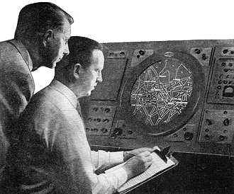
 Radar operators scan skies on long-range
radar. Shown on the scope are air lanes connecting cities. Planes appear as light
spots. Electronically projected map overlay enables the operator to pinpoint plane's
position.
A major step in a sweeping plan for improvement of the nation's air traffic control
system was taken recently, with announcement by the Civil Aeronautics Administration
of an order for 23 long-range radars, biggest single purchase of electronic equipment
in the agency's history.
The radars are the heart of a CAA plan announced last April by Secretary of Commerce
Sinclair Weeks. The plan is designed to handle a fourfold increase in U. S. air
traffic with minimum delay and maximum safety. The new radars will help CAA controllers
accomplish this by scanning the skies for all aircraft up to 200 miles away, depending
on size and altitude.
Raytheon Manufacturing Co. of Waltham, Mass., will design and build the equipment,
which will cost approximately $9,000,000. Deliveries will begin this summer.
The 23 radars will be part of an expanding coast-to-coast traffic control network
of more than 70 civil and military radar installations. The network will give controllers
a picture of aircraft from 15,000 to 70,000 feet in virtually all the U. S. airspace,
and of aircraft at lower altitudes on densely traveled routes. Thus, radar will
serve to track the civil and military jets which move at 600 miles an hour or more
in the higher altitudes, and the conventional aircraft traffic using the lower altitudes.
 Giant 40·foot search antenna to be used
with the new radars. This antenna will be equally effective for jet operation at
35,000 feet and higher or for low-altitude slower aircraft.
Each radar uses a large 40-foot antenna, and effectively covers more than 125,000
square miles of area. A single set will be able to feed up to 15 different monitor
screens simultaneously, so that each controller on duty in a CAA center can have
a picture of traffic movement. At present, with the exception of the radar-equipped
New York and Washington centers, CAA controllers depend on position reports radioed
in by pilots en route. CAA also has radar for surveillance around 34 airports, which
will continue to serve traffic within a range up to 30 miles.
The new equipment employs either linear or circular polarization of the radar
signal so as to minimize the effect of rain or other bad weather interference. Another
feature is an improved moving target indication arrangement that removes radar echoes
from fixed objects, thereby allowing signals from moving aircraft to show up clearly.
Chances of breakdown are reduced because of the use of dual controls and functioning
parts, allowing uninterrupted operations.
 New radars are to be installed at 23 of the 28 heavily circled areas shown below. Remaining 5 areas will use military gear. Light circles show future coverage. New radars are to be installed at 23 of the 28 heavily circled areas shown below. Remaining 5 areas will use military gear. Light circles show future coverage.
Posted October 22, 2021
(updated from original post on 7/15/2013)
|


