| August 1937 Popular Mechanics |
 [Table of Contents] [Table of Contents]
Wax nostalgic about and learn from the history of early
mechanics and electronics. See articles from
Popular Mechanics,
published continuously since 1902. All copyrights hereby acknowledged.
|
If someone asked me
"what does a meteorologist look like?," I would
refer him to this photo in the August 1937 issue of Popular Mechanics
magazine titled "Forecasting the Weather a Year Ahead." Having been heavily
involved in model aviation (and for a brief period full-scale aviation) all my
life, I have always had a keen interest in weather phenomena. In fact, when I
enlisted in the U.S. Air Force, my "guaranteed" job was to be a Weather
Equipment Specialist. In a long list of other disappointments that would follow
my next four years, I was informed while in Basic Training that that
"guaranteed" job was really not available. Long story short, I ended up being an
Air Traffic Control Radar Repairman
instead. Anyway, in 1937 there were no digital or even serious analog computers
available for modeling and predicting weather events. Meteorologists assimilated
data provided via teletype from around the country and large bodies of water,
and generated maps and forecasts based thereupon. Long-term trends had already
been discovered based on ocean temperatures and jet stream characteristics.
Water and atmospheric sondes measured and reported various parameters useful in
predictions. It is amazing they were able to do such a good job. I still follow
the weather closely today, and know that even with vastly more sophisticated
measurement, reporting, and data analysis tools, getting the weather right for
more than a couple days is rare. Pilots are still taught to observe and draw
their own conclusions about weather using visual observations and knowledge of
atmospheric behavior. We're not much closer today to having meaningful
year-ahead weather forecasts as we are to a flying car in every garage and a
personal
tokamak to power every house.
Forecasting the Weather a Year Ahead

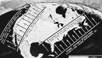
Sketch showing westward shift of air masses which caused unusual
weather.
Everyone wants to know what the weather will be like tomorrow. Weather wizards
who are developing the science of air-mass analysis can tell you not only that but
they can make predictions for the next two or three days that are correct nine times
out of ten. Air-mass analysis is contributing amazingly to the accuracy of weather
forecasts.
Now there is a possibility that the same science may help to foretell the general
climate a whole season in advance. That means that late in the summer, for instance,
forecasters will be able to say whether a cold wet winter or a comparatively mild
one may be expected. Advance information like that has been a major goal of meteorology
for a long time. Such a head start on the weather would mean tremendous savings
to industry.
It is too early in the year to predict next winter's weather, although the forces
that will control it are being studied already. But the conditions that brought
on last winter's floods and unusual conditions were scrutinized as early as last
summer. Last October Dr. Irving P. Krick of the California Institute of Technology
warned citrus growers that they could expect unusually cold weather and heavy frosts
during the winter season. He based his forecast upon a queer shift in what he calls
the semi-permanent atmospheric boundaries that control the general climate in the
United States.
Normally one of these boundaries lies just east of the Rockies and the other
hovers over the Atlantic a few hundred miles at sea. The boundaries mark the limit
of the fairly stable cold continental air mass and separate it on both sides from
warmer and more moist air masses over the oceans. Frequently these boundaries shift
back and forth several hundred miles in a few days but their average geographical
positions seem to be pretty well fixed. Ordinarily, oncoming Pacific air provides
a mild winter along the west coast, and the cold continental air in the middle west
and in the east provides a cold winter climate.

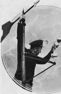
Wind vane and air-speed indicator.

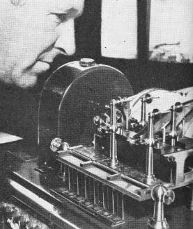
Automatic weather recorder.

Adjusting device which registers data concerning currents
at bottom of ocean.
What Dr. Krick noticed was that the cold continental air mass had shifted to
the west something like 500 miles and for a time it remained more or less fixed
in its new position. The western boundary had moved out over the Pacific. This would
prevent warm ocean air from reaching the west coast and led to the forecast of a
cold winter for the citrus growers. At the same time, the eastern boundary of the
continental air mass had moved inland as far as the west slope of the Appalachians.
Put in simple words, this suggested that the forces influencing weather had shifted
west for the time being and that in anyone place the weather conditions that normally
occurred a few hundred miles to the east might be expected, modified by local conditions.
That meant unusual weather everywhere. In the east, exposure to the warm Atlantic
air indicated a relatively warm winter with thaws and floods. That is precisely
what happened.
The displacement of the continental air mass also seems to account for the devastating
floods along the Ohio and Mississippi rivers. The thaws west of the Appalachians
contributed their share and the same displacement of the continental air mass that
caused them also re-routed the storms that normally travel from west to east along
the northern border of the country. Starting out over the Pacific, the storms encountered
the cold continental air sooner than usual and were shunted far to the south where
they described circular tracks across Mexico and the Gulf and finally made their
way up the Mississippi valley. In crossing the Gulf the storm centers picked up
tremendous quantities of moisture that were later precipitated in the flood area.
The same westward shift also provides a reason for the drought in the middle-western
dust bowl last summer. Ordinarily heavy showers occur east of the Rockies along
the zone of activity that marks the western boundary of the continental air mass.
When the boundary moved to the west the showers fell as usual, but last summer the
boundary happened to lie over Utah and Arizona instead of the states more to the
east. Those states were robbed of their normal summer rains, resulting in the drought.
Even if this extension of air-mass analysis is going to provide the key to accurate
long-range forecasts, Dr. Krick won't be ready to depend upon it until the reasons
for the behavior of the air masses can be found. One explanation may be found in
the fact that last summer unusually high temperatures were recorded by sea-water
thermometers in the north Pacific. This suggests that the warm sea water in turn
warmed the air above it, allowing the air to pick up more moisture than usual. In
turn, this made the air lighter than it is ordinarily. Humid air is always lighter
than dry air. The result was that the cold dense air of the continental air mass
was able to flow in under the warm air, shouldering it upward and extending its
own cold influence clear to the west coast. Ascending warm air usually meets colder
temperatures in the higher altitudes and this results in condensation and then precipitation.
It may be that the real key to the climate, at least for part of the country, may
be found in the sea-water temperatures of the north Pacific.
Right now air-mass analysis is serving the weather bureau, air lines, motion-picture
studios, and scores of different industries. By knowing what the weather will be
like a day or so in advance, motion-picture studios are able to plan their outdoor
camera schedules ahead of time with fair certainty. Real-estate concerns depend
upon weather forecasts to plan their week-end activities and advertising, and even
wayside eating stands regulate their orders for food depending upon whether the
forecasts are for fair or dull weather.
Air-mass analysis got its start when it was learned that large portions of the
earth's atmosphere, covering as much as several million square miles and extending
to heights of six or seven miles, have rather uniform characteristics. Usually an
air mass from the polar regions is extremely cold and dry while an air mass moving
up from the tropics is warm and humid. These air masses frequently collide and the
dissimilarity of the air in the two masses results in atmospheric disturbances along
the boundaries that separate them. Cold air is heavier than warm moist air, so the
polar air mass begins to slope in under the warm mass, pushing its outer fringe
upward. This slope between the cold and warm air is usually at the ratio of one
to 100, so that if one were standing in cold air 100 miles from the line where cold
air is meeting warm air at the surface, he would find warm air one mile above him.
There is a continual struggle going on between these polar and tropical air masses
or currents. The usual result of each meeting of two different masses is clouds
of precipitation, caused by the boosting upward of the warm air to altitudes where
the moisture starts to condense.

Demonstrating how cold-air masses flow under and lift warm air.

Air-line meteorologist plotting top of cloud bank expected six
hours in the future. Temperature information radioed by transport pilots is used
in this work.

Weather-recording instruments and radio transmitter which are
attached to small free balloon and sent to heights of ten to twelve miles. In foreground
is machine which automatically registers on tape the weather data received from
the balloon's transmitter.
This is a rough rule-of-thumb outline of the air-mass system. To accurately gauge
the weather by it, forecasters have to assemble on charts hundreds of reports coming
in by radio and telegraph from airplanes, ships and ground weather stations. Each
air mass is different, but on the charts the migrations of the masses may be plotted
several days ahead of the time that they reach a district, and in that way the probable
weather disturbances and their probable times of arrival are anticipated.
"Climate is merely a summation of weather, and weather from day to day results
from disturbances along the atmospheric fronts," says Dr. Krick. "This gives us
a start in attempting seasonal weather forecasts, for if the semi-permanent atmospheric
fronts during the seasons of the year can be anticipated the kinds of weather associated
with them may be determined, and thus the climate of the region.
"Although the climate of the earth is not changing appreciably over long periods
of time, certain departures from the so-called normal weather occur from year to
year, such as the floods in the Ohio valley and the frosts in southern California
that happened last winter. These developments are explained and in fact were anticipated
by a shift in the semi-permanent fronts that were observed in the spring of 1936.
"When the causes of such shifts in the principal atmospheric boundaries can be
determined we shall be able to anticipate long in advance the abnormalities that
result in seasonal weather. Then these predictions should be just as accurate as
the present forecasts of the day-to-day changes in the weather."

Measuring snow to determine quantity of water content.
|


