Electronics & High Technology Components
- See Full List of AI Topics -

Radiosondes are essential instruments in atmospheric science, providing critical
data for weather forecasting, climate research, and military operations. These lightweight,
battery-powered devices are carried aloft by weather balloons to measure atmospheric
parameters such as temperature, pressure, and humidity. The rawinsonde, an extension
of this technology, also measures wind speed and direction by tracking its position
during ascent through the atmosphere. Together, they have significantly advanced
meteorological science since their invention.

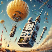
Image of a radiosonde as generated by ChatGPT. It of course looks
nothing like a real radiosonde, but the theme is accurate.
The radiosonde was invented in the 1920s by French meteorologist
Robert Bureau (known in meteorologist circles as the weather Bureau - LOL) and independently
by Russian engineer Pavel Molchanov in 1930. Molchanov's version, considered the
first practical design, was launched on January 30, 1930. It transmitted temperature
and pressure data back to Earth via radio signals, enabling real-time atmospheric
profiling. The rawinsonde was developed later, incorporating tracking systems to
record wind data by determining the instrument's position relative to the launch
site. This innovation required advancements in radio direction-finding and radar
technologies.
Modern instruments for atmospheric measurements are produced by several companies
worldwide, including Vaisala (Finland), Lockheed Martin (United States), Meteolabor
(Switzerland), and Meisei Electric (Japan). These companies design tools with high
precision and durability to withstand harsh atmospheric conditions. Vaisala, one
of the leading manufacturers, has been a pioneer in this field, introducing the
RS series of instruments widely used by meteorological agencies.
Although both devices share similar designs and measurement capabilities, they
differ in their additional functionalities. A radiosonde typically includes sensors
for temperature, humidity, and pressure, which are connected to a transmitter that
sends data to ground-based receivers. In contrast, a rawinsonde incorporates these
features and adds a GPS or radio-theodolite system for wind measurement. By tracking
its movement, wind speed and direction at various altitudes can be calculated, providing
a complete atmospheric profile.
These instruments are launched using helium or hydrogen-filled weather balloons,
which ascend to altitudes of up to 35 kilometers (115,000 feet). During the ascent,
they continuously transmit data back to ground stations. Recovery is not typically
planned, as the devices are designed to be disposable due to their low cost and
the difficulty of retrieval. Some advanced systems, however, incorporate parachutes
to slow descent, allowing for occasional recovery.
Measurements obtained include temperature, relative humidity, atmospheric pressure,
wind speed, and wind direction. This data is critical for understanding weather
patterns, predicting storms, and studying climate change. Instruments such as thermistors,
capacitive hygrometers, and aneroid barometers are commonly used onboard. For wind
tracking, GPS receivers or radar reflectors are employed.
The historical development of these tools reflects the evolution of meteorological
science. Early experiments in the 1930s laid the foundation for routine upper-air
observations. During World War II, the military extensively used them to improve
artillery targeting and aviation safety. Post-war advancements brought miniaturization
and increased accuracy, making them standard tools in meteorology. In the 1960s,
the adoption of radar and GPS technologies enabled comprehensive wind measurements,
leading to their widespread use.
Applications span military, civilian, industrial, and research domains. In the
military, they provide crucial data for missile trajectory calculations, flight
planning, and surveillance. Civilian uses include weather forecasting and disaster
preparedness, where accurate atmospheric data are indispensable. Industrial applications
involve monitoring atmospheric conditions for activities such as oil drilling and
construction. Research institutions use these instruments to study atmospheric phenomena,
validate satellite data, and improve numerical weather prediction models.
These atmospheric measurement devices can be launched not only by balloons but
also by rockets, aircraft, and drones, depending on the application and required
data resolution. Rocketsondes are used for high-altitude measurements beyond the
reach of balloons, while aircraft and drones enable targeted observations in specific
regions. The cost varies, with basic versions priced at around $200–500 per unit,
while advanced models with GPS or specialized sensors may cost significantly more.
 This content was generated by primarily
with the assistance of ChatGPT (OpenAI), and/or
Gemini (Google), and/or
Arya (GabAI), and/or Grok
(x.AI), and/or DeepSeek artificial intelligence
(AI) engines. Review was performed to help detect and correct any inaccuracies; however,
you are encouraged to verify the information yourself if it will be used for critical
applications. In all cases, multiple solicitations to the AI engine(s) was(were)
used to assimilate final content. Images and external hyperlinks have also been
added occasionally - especially on extensive treatises. Courts have ruled that AI-generated
content is not subject to copyright restrictions, but since I modify them, everything
here is protected by RF Cafe copyright. Many of the images are likewise generated
and modified. Your use of this data implies an agreement to hold totally harmless
Kirt Blattenberger, RF Cafe, and any and all of its assigns. Thank you. Here is
Gab AI in an iFrame. This content was generated by primarily
with the assistance of ChatGPT (OpenAI), and/or
Gemini (Google), and/or
Arya (GabAI), and/or Grok
(x.AI), and/or DeepSeek artificial intelligence
(AI) engines. Review was performed to help detect and correct any inaccuracies; however,
you are encouraged to verify the information yourself if it will be used for critical
applications. In all cases, multiple solicitations to the AI engine(s) was(were)
used to assimilate final content. Images and external hyperlinks have also been
added occasionally - especially on extensive treatises. Courts have ruled that AI-generated
content is not subject to copyright restrictions, but since I modify them, everything
here is protected by RF Cafe copyright. Many of the images are likewise generated
and modified. Your use of this data implies an agreement to hold totally harmless
Kirt Blattenberger, RF Cafe, and any and all of its assigns. Thank you. Here is
Gab AI in an iFrame.
AI Technical Trustability Update
While working on an update to my
RF Cafe Espresso Engineering Workbook project to add a couple calculators about
FM sidebands (available soon). The good news is that AI provided excellent VBA code
to generate a set of Bessel function
plots. The bad news is when I asked for a
table
showing at which modulation indices sidebands 0 (carrier) through 5 vanish,
none of the agents got it right. Some were really bad. The AI agents typically explain
their reason and method correctly, then go on to produces bad results. Even after
pointing out errors, subsequent results are still wrong. I do a lot of AI work
and see this often, even with subscribing to professional versions. I ultimately
generated the table myself. There is going to be a lot of inaccurate information
out there based on unverified AI queries, so beware.
Electronics & High Tech
Companies | Electronics &
Tech Publications | Electronics &
Tech Pioneers | Electronics &
Tech Principles |
Tech Standards Groups &
Industry Associations | Societal
Influences on Technology
|


